The World Control Map: Labeled is a category.geography Montessori material designed for children aged 3-6, crafted by Nienhuis Montessori to AMI standards.
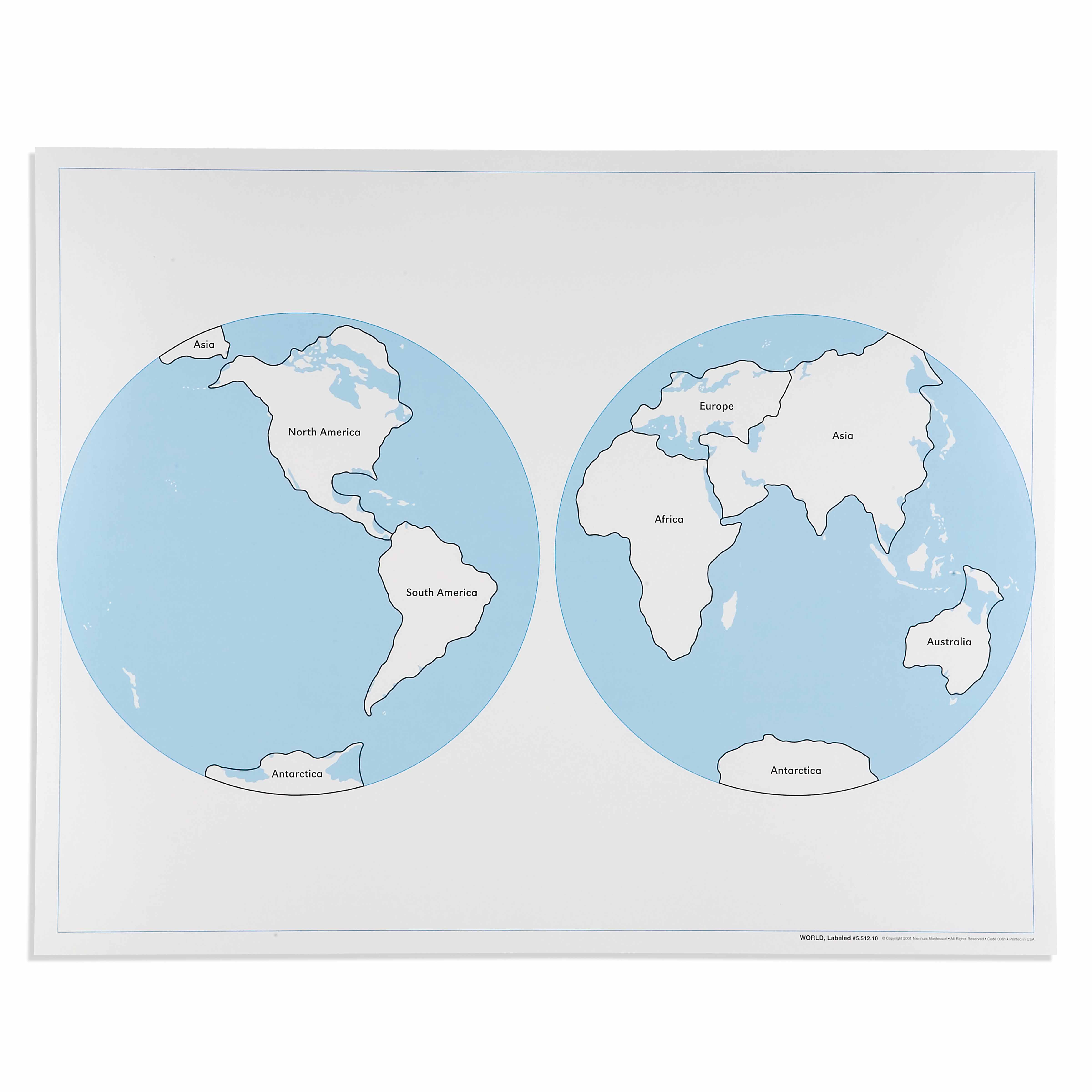
This World Control Map: Labeled presents Earth's continents in a clear two-hemisphere projection, perfect for the Montessori geography curriculum. The laminated surface allows children to trace continental boundaries with their fingers while learning continent names, supporting the concrete-to-abstract progression essential to Montessori education. Each continent is distinctly outlined with bold black borders and clearly labeled text, making this an ideal reference map for geography lessons and cultural studies.
“Education is a natural process spontaneously carried out by the human individual, and is acquired not by listening to words but by experiences upon the environment.”— Maria MontessoriEducation for a New World
“The child is both a hope and a promise for mankind.”
— Maria Montessori, Education and Peace
The World Control Map: Labeled serves as a concrete geographic reference point in the Montessori environment, offering children aged 3-6 their first systematic introduction to Earth's continents. This laminated map with its bold black continental borders allows young fingers to trace the shapes of Africa, Asia, Europe, and other landmasses while simultaneously seeing their written names. The two-hemisphere projection presents our planet's geography in a format that children can comprehend, moving from sensorial exploration of shapes to abstract understanding of continental names. The labeled format bridges the gap between the unlabeled puzzle maps children manipulate and the more complex political maps they will encounter later. By providing continent names alongside clear visual boundaries, this control map respects the child's need for order while introducing geographic nomenclature at the precise moment when language acquisition is most active. The durable laminated surface invites repeated tactile exploration, essential for the young child who learns through movement and touch.
Each order includes everything needed for proper presentation and long-term use.
Follow the Montessori method of presentation for optimal child development.
Invite the child to explore the map freely, observing which continents they notice first
Demonstrate tracing one continent's border slowly with your index finger, then reading its name aloud
Encourage the child to trace each continent while you read the names together
Play simple location games: 'Can you find Europe?' or 'Which continent is the largest?'
Each material supports multiple areas of child development simultaneously.
Children develop understanding of Earth's continents and their relationships through visual and tactile exploration of the map's clear boundaries.
Reading continent labels reinforces vocabulary and connects written words with geographic concepts in meaningful context.
The distinct continental shapes and boundaries help children recognize and differentiate between land masses, preparing for more detailed geography work.
This control map serves as the basis for understanding world cultures, peoples, and environments in subsequent Montessori cultural studies.
Designed for child-sized hands
Professional tips from AMI-trained guides to maximize the educational value of this material.
“Display the map at children's height - they should be able to touch all continents comfortably without stretching”
'hemisphere,' 'continent,' 'ocean' as children show readiness
Connect the flat map representation to the classroom globe regularly to build three-dimensional understanding
Use the map during cultural discussions - when reading stories or discussing foods from different continents
Everything you need to know about this material.
The World Control Map is made from durable laminated material that allows children to trace continental boundaries with their fingers. The laminated surface is easy to clean and designed to withstand repeated use in the classroom. Please check with the supplier for exact dimensions.
This World Control Map includes clearly printed continent names on each landmass, making it ideal for children who are learning to read or associate written names with geographical locations. The labeled version serves as a reference tool while children work with unlabeled puzzle maps and other geography materials.
This map is designed for ages 3-6 years, aligning with the Montessori primary curriculum. The two-hemisphere projection and bold black borders make it visually accessible for young children, while the labeled continents support early reading and geography skills development.
Children use this as a reference when working with the Montessori world puzzle map, continent boxes, and other geography materials. They can trace continents with their fingers, match continent shapes, and begin associating continent names with their locations, supporting the concrete-to-abstract learning progression.
This map helps children develop spatial awareness, recognize continental shapes and positions, learn continent names, and understand Earth's geography. It supports vocabulary development, reading skills, and serves as a foundation for cultural studies and more advanced geography work.
Can't find what you're looking for?
Contact Our Experts
Share your experience with this material and help other educators and parents.

