The Seas And Oceans Control Map: Labeled is a category.geography Montessori material designed for children aged 3-6, crafted by Nienhuis Montessori to AMI standards.
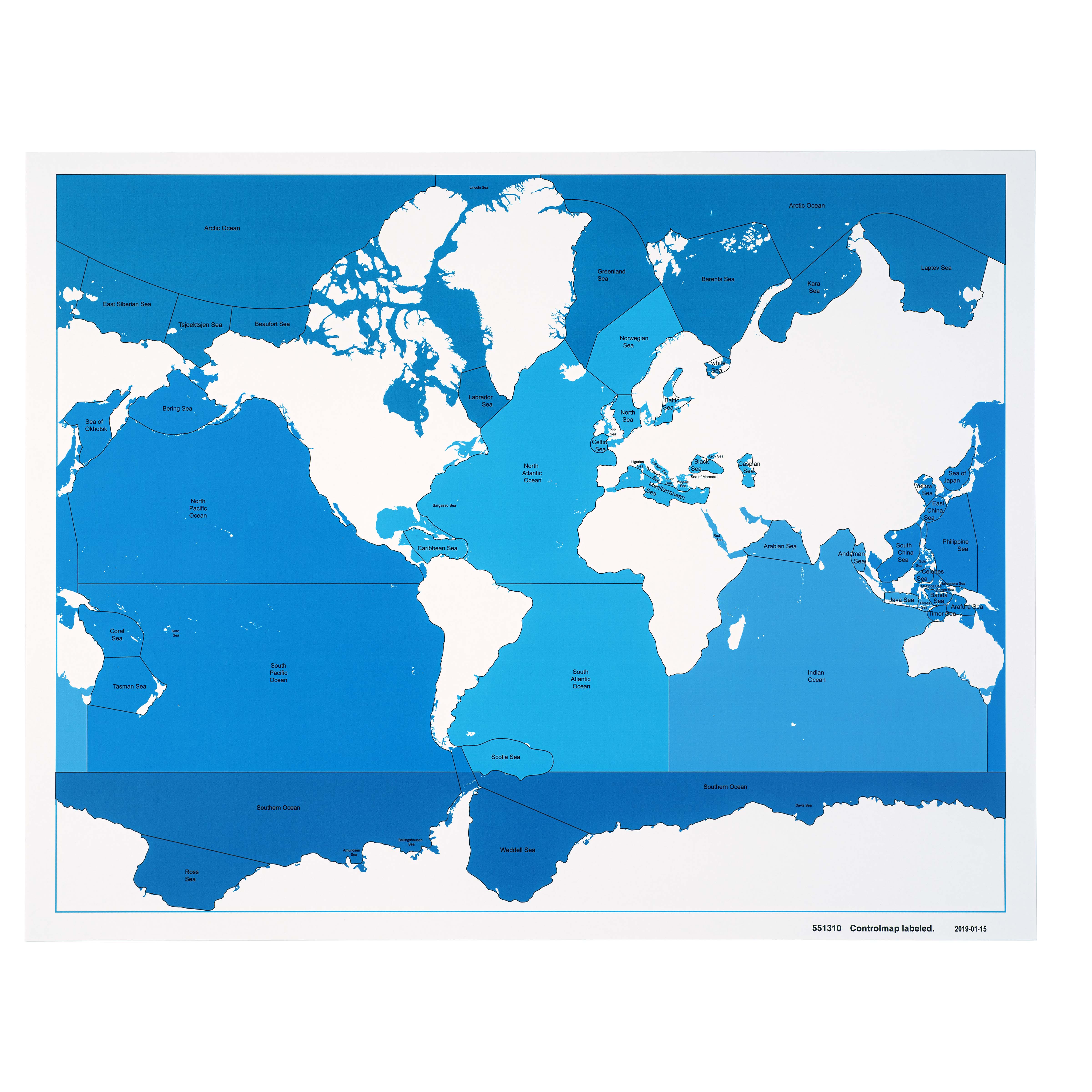
This labeled control map introduces children to the world's major seas and oceans through a clear, color-coded design. The laminated map features blue water bodies with printed labels against white continents, helping children learn geographic names and positions while developing their understanding of Earth's water systems and continental relationships.
“Education is a natural process spontaneously carried out by the human individual, and is acquired not by listening to words but by experiences upon the environment.”— Maria MontessoriEducation for a New World
“The child is both a hope and a promise for mankind.”
— Maria Montessori, Education and Peace
The Seas And Oceans Control Map serves as a concrete geographic reference that transforms abstract water body names into visual, memorable locations. This laminated map with its blue water bodies printed against white continents creates clear visual boundaries that young children can trace with their fingers while reading each label. The control aspect of this map—having all names permanently printed—allows children to verify their work independently when using unlabeled puzzle maps or creating their own geographic drawings. By presenting seas and oceans as distinct blue regions with readable labels, the map satisfies children's need to understand their planet's structure through direct visual exploration. The color-coded design of blue water against white land masses creates strong visual memory associations that help three-to-six-year-olds internalize geographic relationships naturally through repeated reference.
Each order includes everything needed for proper presentation and long-term use.
Follow the Montessori method of presentation for optimal child development.
Invite the child to explore the map, starting with finding the ocean nearest your location
Read each ocean label slowly, pointing to the text and then tracing the water body
Compare sizes of different water bodies using descriptive language
Identify which continents border each ocean or sea
Every material is carefully selected for durability, safety, and authentic Montessori experience.
Sourced from sustainably managed European forests. Beechwood is chosen for its exceptional durability, smooth grain, and natural warmth that invites touch.
Natural, unbleached cotton in child-friendly colors. The fabric provides the right amount of friction for developing fingers while being gentle on sensitive skin.
Water-based, child-safe finish that meets the strictest European safety standards. Designed to withstand years of daily use without chipping or peeling.
Each material supports multiple areas of child development simultaneously.
Children learn to identify and name Earth's major water bodies while understanding their relative positions and relationships to continents.
Labeled names provide reading practice in a meaningful context, reinforcing letter recognition and word formation skills.
The map's grid system and continental outlines help children develop understanding of location, direction, and spatial relationships.
Learning ocean and sea names fosters awareness of Earth's water systems and their importance to global geography.
Designed for child-sized hands
Professional tips from AMI-trained guides to maximize the educational value of this material.
“Display the map at child height on a wall or easel for easy daily reference”
Use the map during circle time to discuss weather patterns or marine life habitats
Create matching cards with ocean names to reinforce label recognition
Laminated surface allows for dry-erase markers to highlight specific seas during lessons
Everything you need to know about this material.
This control map typically measures approximately A3 size (297 x 420mm) when laminated, making it easy for young children to handle while providing clear visibility of all labeled seas and oceans.
This labeled version includes printed names of all seas and oceans directly on the map, serving as a control chart for children to check their work when using unlabeled maps or puzzle pieces in geography activities.
Yes, the clear color-coding and simple design make it accessible for 3-year-olds who can begin recognizing shapes and patterns, though they'll gradually develop reading skills to identify the labels as they grow.
Children learn to identify major water bodies, understand the relationship between continents and oceans, develop spatial awareness, and begin recognizing that Earth is covered mostly by water.
The lamination provides excellent durability for classroom use, protecting against spills, tears, and frequent handling while maintaining clear visibility of the blue water bodies and white continents.
Can't find what you're looking for?
Contact Our Experts
Share your experience with this material and help other educators and parents.


