The Puzzle Map: Europe is a category.geography Montessori material designed for children aged 3-6, crafted by Nienhuis Montessori to AMI standards.
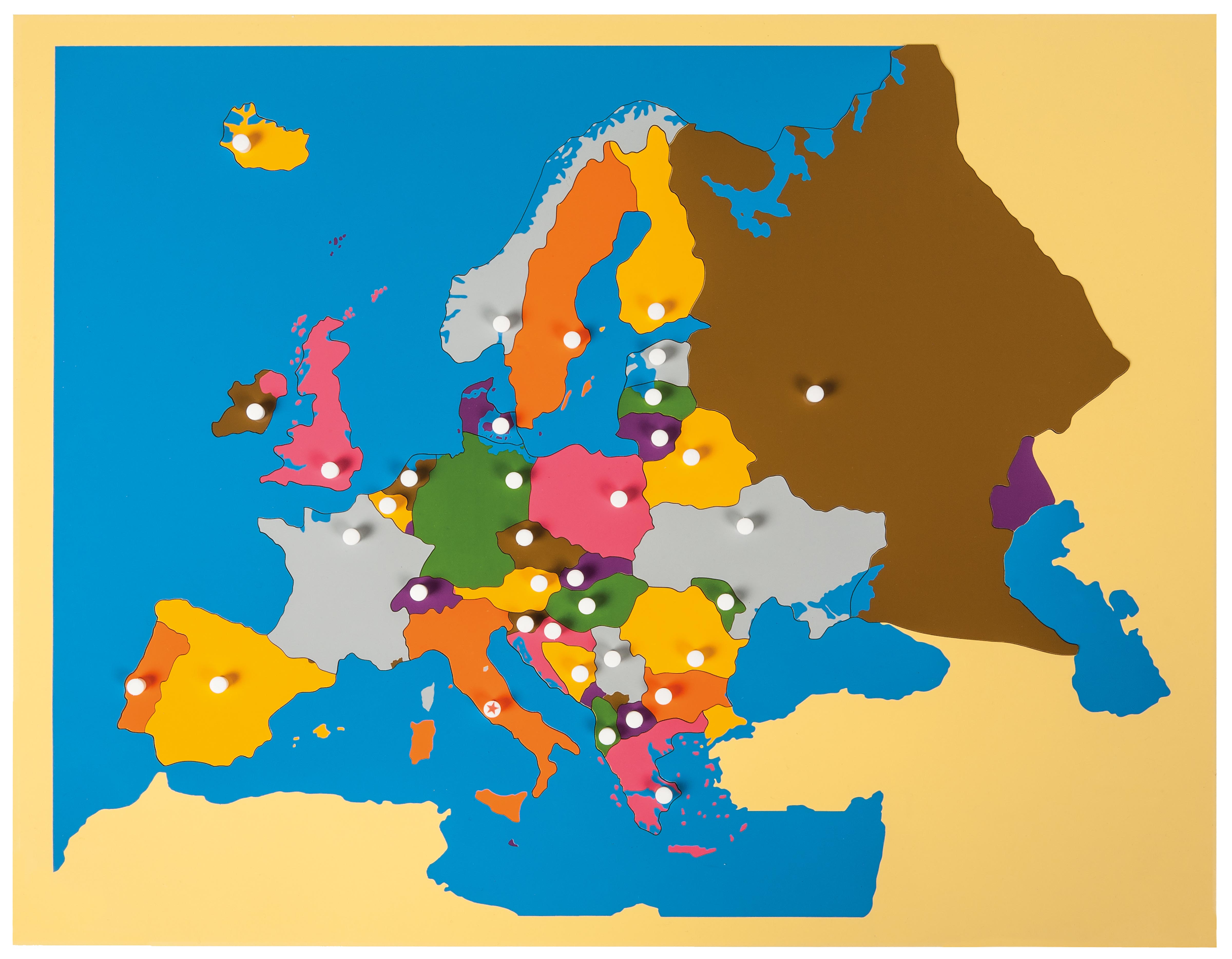
This wooden Europe puzzle map introduces children to the continent's geography through hands-on exploration. Each country is a removable puzzle piece with its own knob handle, painted in distinct colors to help children identify and memorize European nations. The map features a sturdy wooden base with water areas shown in traditional blue, supporting the Montessori approach to concrete geographical learning.
“Education is a natural process spontaneously carried out by the human individual, and is acquired not by listening to words but by experiences upon the environment.”— Maria MontessoriEducation for a New World
“The child is both a hope and a promise for mankind.”
— Maria Montessori, Education and Peace
The Europe puzzle map serves as a concrete introduction to political geography for young children, transforming abstract continental boundaries into tangible wooden pieces. Each country's distinct color and removable form allows children to isolate and explore individual European nations through their senses. The knob handles on each country piece develop the three-finger grip while building geographical awareness. Through repeated manipulation of these wooden countries, children internalize Europe's political divisions before they can read maps abstractly. The puzzle map's blue water areas provide clear visual boundaries between land and sea, helping children understand Europe's relationship with surrounding waters. This wooden map bridges the gap between a child's immediate environment and the wider world, making distant countries as real and touchable as objects in their classroom. The Europe puzzle exemplifies Montessori's principle of moving from concrete to abstract learning, as children first handle physical countries before progressing to flat maps and globes.
Each order includes everything needed for proper presentation and long-term use.
Follow the Montessori method of presentation for optimal child development.
Demonstrate removing one country piece using the knob with your dominant hand's three-finger grip
Place the removed piece to the right of the map frame, naming the country clearly
Trace around the empty space with your index finger, then trace the puzzle piece
Return the piece to its space, demonstrating how to align edges precisely
Invite the child to remove and replace the same country
Each material supports multiple areas of child development simultaneously.
Children develop spatial understanding of European countries and their relationships through hands-on manipulation.
Grasping knobs and fitting puzzle pieces refines pincer grip and hand-eye coordination.
Distinct colors and shapes help children distinguish between countries and memorize their locations.
Early exposure to European geography prepares children for future studies in history, culture, and current events.
Designed for child-sized hands
Professional tips from AMI-trained guides to maximize the educational value of this material.
“Present peninsula countries first (Italy, Spain, Greece) as their distinctive shapes are easier to recognize and remember”
Create a basket of European cultural objects or photographs to pair with puzzle work, connecting countries to real-world associations
coastal vs. landlocked countries, large vs. small nations
Document which countries each child can identify to track geographical knowledge development over time
Everything you need to know about this material.
This puzzle map is designed for children ages 3-6 years. The knob handles are sized for small hands, and the difficulty level aligns with early childhood development stages when children begin exploring geography concepts.
The puzzle includes major European countries as individual pieces. Smaller nations may be grouped together or represented as part of larger regions, following traditional Montessori geography materials standards for this age group.
The puzzle features a sturdy wooden base with removable wooden country pieces. Each piece has a knob handle for easy grasping. Water areas are painted in blue, while countries use distinct colors. Specific dimensions vary but are designed for tabletop or floor work.
This material follows Montessori principles by providing concrete, hands-on learning. Children physically handle each country, building muscle memory and spatial awareness. The color-coding and tactile experience help children internalize geographical concepts before moving to abstract map reading.
Yes, this puzzle integrates perfectly with other Montessori geography materials like continent boxes, flag work, and cultural folders. It serves as a foundation for more advanced geography studies and can be paired with books, pictures, and cultural objects from European countries.
Can't find what you're looking for?
Contact Our Experts
Share your experience with this material and help other educators and parents.

