The Puzzle Map: Canada is a category.geography Montessori material designed for children aged 3-6, crafted by Nienhuis Montessori to AMI standards.
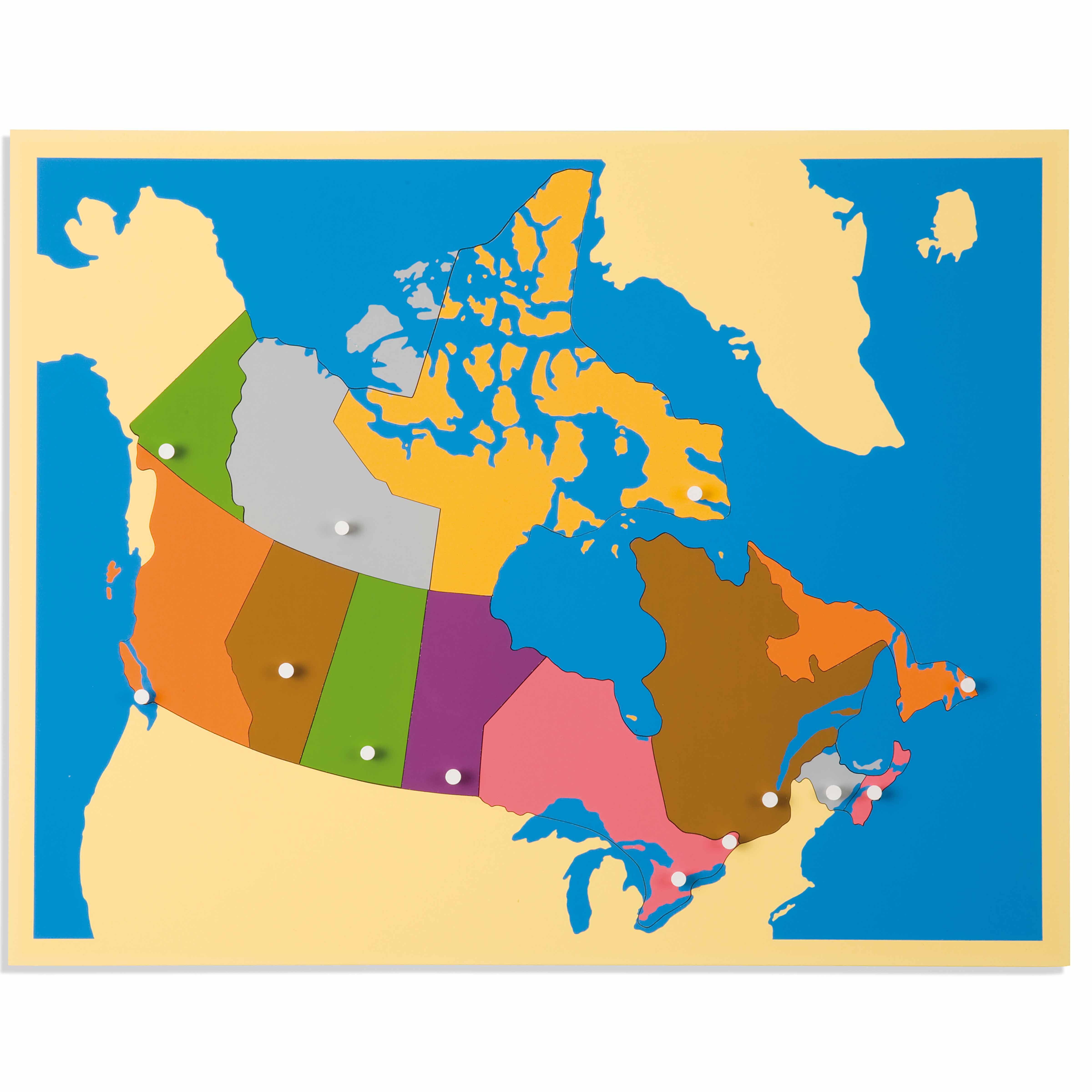
This beautifully crafted wooden Puzzle Map of Canada introduces children to the country's provinces and territories through hands-on exploration. Each removable puzzle piece represents a distinct region, featuring precision-cut borders and white control knobs that support the child's developing pincer grip while building geographic awareness and spatial reasoning skills.
“Education is a natural process spontaneously carried out by the human individual, and is acquired not by listening to words but by experiences upon the environment.”— Maria MontessoriEducation for a New World
“The child is both a hope and a promise for mankind.”
— Maria Montessori, Education and Peace
The Puzzle Map of Canada transforms abstract political boundaries into concrete, manipulable pieces that children can hold, trace, and assemble. Each wooden province and territory piece isolates a specific region, allowing children to build mental maps through repeated handling and placement. The white control knobs positioned on each piece serve dual purposes: they indicate capital city locations while providing the precise grip point needed for developing pincer control. This puzzle map bridges the child's concrete operational thinking with abstract geographic concepts by making invisible borders tangible. The distinct shapes of Canada's provinces—from tiny Prince Edward Island to sprawling Quebec—create natural points of interest and comparison. Through assembling this wooden map, children discover relationships between regions while the physical act of fitting pieces together mirrors how provinces unite to form one nation. The puzzle format respects the child's need to learn through movement and repetition, as each reassembly deepens geographic understanding.
Each order includes everything needed for proper presentation and long-term use.
Follow the Montessori method of presentation for optimal child development.
Invite the child to remove all pieces using the knobs, placing them randomly on the mat
Select one piece and trace its outline with your finger before placing it in the frame
Continue placing pieces one at a time, allowing the child to take over when ready
When complete, admire the assembled map together
Every material is carefully selected for durability, safety, and authentic Montessori experience.
The durable wooden frame provides a stable foundation for repeated use while offering the natural texture and weight that grounds the child's geographic explorations.
Each material supports multiple areas of child development simultaneously.
Children develop spatial understanding of Canada's political divisions while building a mental map of provinces and territories.
The white control knobs support proper pincer grip development as children carefully remove and replace each province piece.
Distinguishing between provinces by shape and position refines visual perception and attention to detail.
Concrete exploration of Canada's geography lays the foundation for understanding regional diversity and national identity.
Designed for child-sized hands
Professional tips from AMI-trained guides to maximize the educational value of this material.
“Present the map without naming provinces initially—let shape recognition develop first”
Create a control map showing provinces in outline form for independent checking
Rotate which pieces you remove during presentations to maintain interest
Connect map work to children's personal experiences ('Your grandmother lives in this province')
Everything you need to know about this material.
This puzzle map is designed for children ages 3-6 years, aligning with the Montessori early childhood curriculum when children are developing spatial awareness and beginning to understand their place in the world.
The puzzle is crafted from high-quality, smooth wooden pieces with precision-cut borders. Each province and territory is a separate piece with a white control knob for easy handling and proper pincer grip development.
Children learn Canadian geography through hands-on manipulation, building muscle memory of provincial shapes and locations. The puzzle encourages discussions about different regions, develops spatial reasoning, and creates a concrete foundation for abstract geographic concepts.
This material develops fine motor skills through pincer grip practice, spatial intelligence through fitting pieces, geographic awareness of Canada's regions, problem-solving abilities, and concentration as children work to complete the map independently.
Begin by showing how to carry the puzzle with two hands, demonstrate removing and replacing one piece at a time using the knob, and gradually introduce province names. Allow the child to explore independently, and later add extensions like matching province cards or discussing regional characteristics.
Can't find what you're looking for?
Contact Our Experts
Share your experience with this material and help other educators and parents.


