The Oceans Control Map: Labeled is a category.geography Montessori material designed for children aged 3-6, crafted by Nienhuis Montessori to AMI standards.
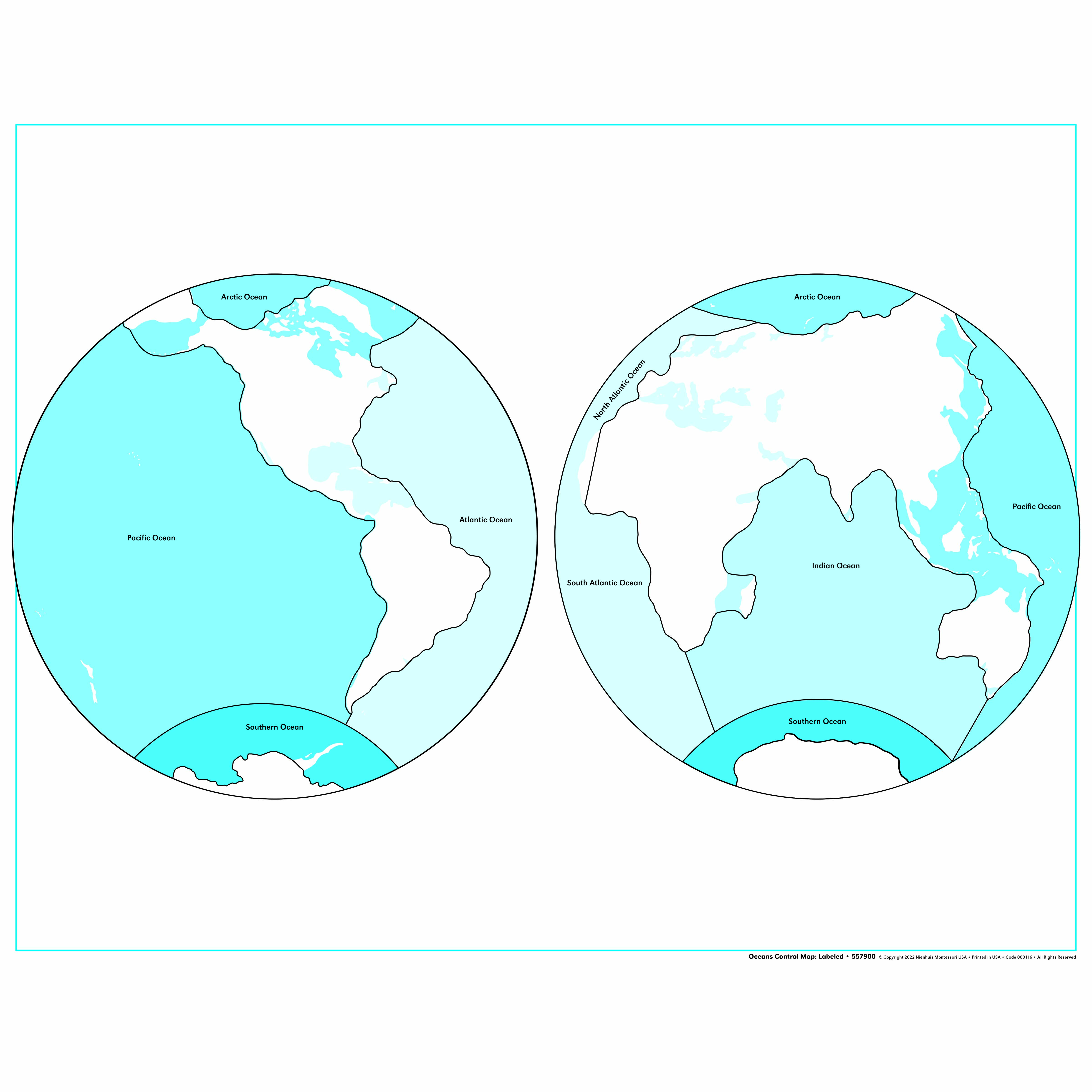
This labeled control map presents Earth's five oceans in a clear dual-hemisphere projection, supporting the child's exploration of global water bodies and their relationship to continents. The laminated surface ensures durability for repeated classroom use while the labeled format provides immediate visual confirmation during the child's self-directed geography work.
“Education is a natural process spontaneously carried out by the human individual, and is acquired not by listening to words but by experiences upon the environment.”— Maria MontessoriEducation for a New World
“The child is both a hope and a promise for mankind.”
— Maria Montessori, Education and Peace
The Oceans Control Map serves as a concrete geographic reference that transforms abstract water body concepts into visible, nameable entities for the young child. By presenting Earth's five oceans in dual-hemisphere projection, this map creates a visual bridge between the child's sensorial experiences of water and the vast oceanic systems covering our planet. The labeled format of this control map provides the exact language the child needs at the moment of discovery, eliminating guesswork and building confidence in geographic terminology. Unlike globe work where oceans curve away from view, this flat projection allows the child to see all five oceans simultaneously, revealing their interconnected nature. The laminated surface invites repeated tracing and exploration, while the clear labels offer immediate self-correction when matching with puzzle pieces or three-part cards. This control map addresses the child's need to understand their place in the world by first establishing where the great waters lie in relation to the land masses they're beginning to recognize.
Each order includes everything needed for proper presentation and long-term use.
Follow the Montessori method of presentation for optimal child development.
Invite the child to feel water with their fingertips, then dry hands
Present the map, tracing the outline of one ocean with your finger while naming it slowly
Invite the child to trace the same ocean while repeating its name
Continue with 2-3 more oceans in the same lesson, depending on the child's interest
Play a simple game: 'Can you show me the Atlantic Ocean?'
Every material is carefully selected for durability, safety, and authentic Montessori experience.
Sourced from sustainably managed European forests. Beechwood is chosen for its exceptional durability, smooth grain, and natural warmth that invites touch.
Natural, unbleached cotton in child-friendly colors. The fabric provides the right amount of friction for developing fingers while being gentle on sensitive skin.
Water-based, child-safe finish that meets the strictest European safety standards. Designed to withstand years of daily use without chipping or peeling.
Each material supports multiple areas of child development simultaneously.
Builds understanding of Earth's major water bodies and their spatial relationships to continents.
Introduces ocean vocabulary through clear labeling, supporting reading and geographic nomenclature.
Develops ability to distinguish between different ocean boundaries and their characteristic shapes.
Fosters understanding of Earth as an interconnected system of land and water masses.
Designed for child-sized hands
Professional tips from AMI-trained guides to maximize the educational value of this material.
“Present oceans in relation to familiar continents - 'The Atlantic Ocean lies between Europe and North America'”
Keep a small globe nearby to show how the flat map represents the round Earth
'The Pacific Ocean is the largest ocean'
Use the map during circle time to mark ocean-related current events or animal migrations
Everything you need to know about this material.
This labeled oceans control map is specifically designed for children ages 3-6 years, aligning with the Montessori early childhood curriculum for geography exploration.
The dual-hemisphere projection shows all five oceans in their proper global context, helping children visualize how water bodies connect around the Earth and relate to different continents.
Yes, the map features a laminated surface that protects it from spills, tears, and frequent handling, making it ideal for repeated use in busy Montessori classrooms.
The labeled format provides immediate visual confirmation, allowing children to check their work independently when matching ocean names or exploring geography without constant adult intervention.
The map displays all five major oceans: Pacific, Atlantic, Indian, Arctic, and Southern (Antarctic) Oceans, with clear labels for each water body.
Can't find what you're looking for?
Contact Our Experts
Share your experience with this material and help other educators and parents.


