The Mexico Control Map: Labeled is a category.geography Montessori material designed for children aged 3-6, crafted by Nienhuis Montessori to AMI standards.
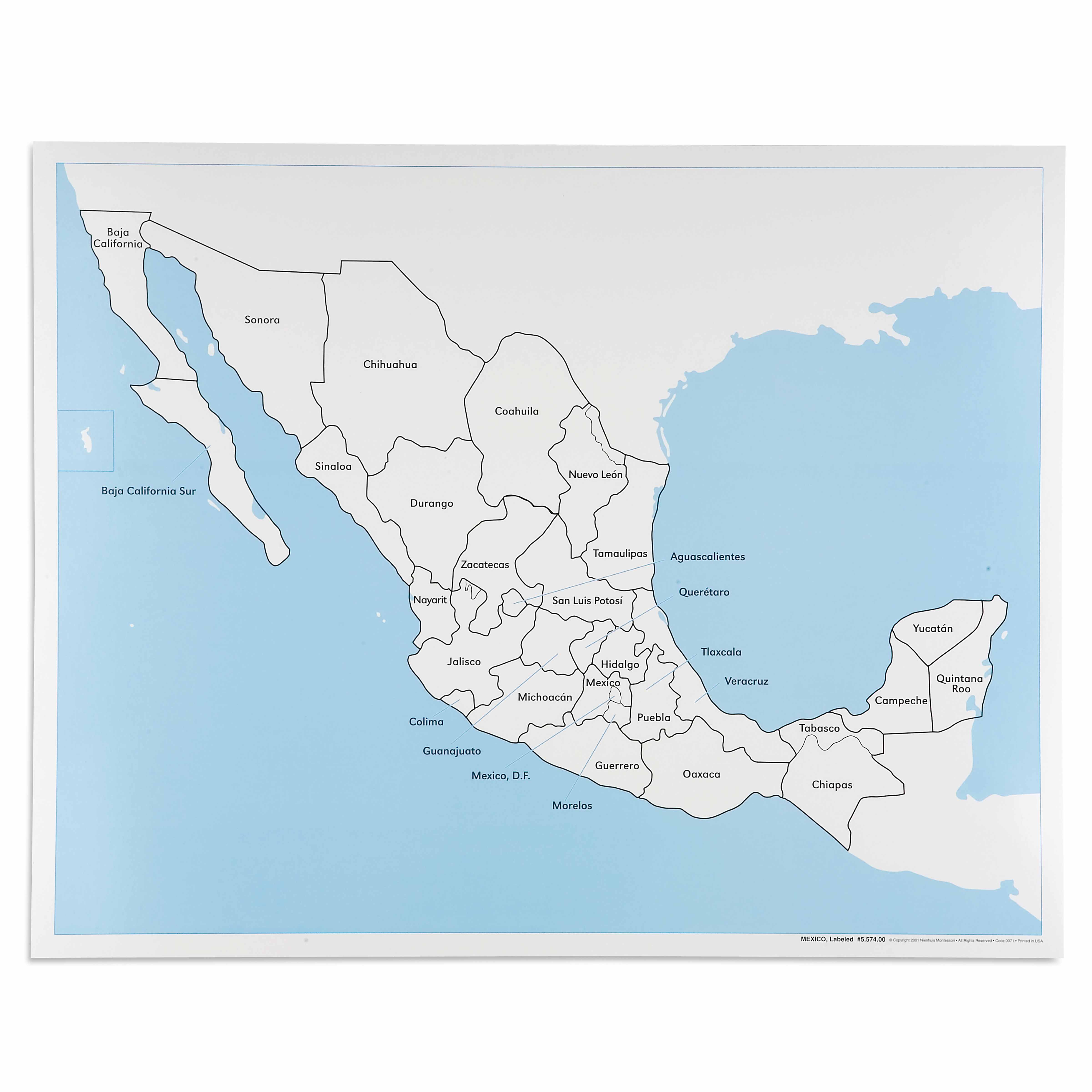
This labeled control map of Mexico provides children with a comprehensive reference for exploring Mexican geography. Each of Mexico's 31 states and Federal District is clearly labeled, along with surrounding bodies of water including the Pacific Ocean, Gulf of Mexico, and Caribbean Sea. The durable laminated surface ensures this essential geography material withstands repeated use in the Montessori classroom.
“Education is a natural process spontaneously carried out by the human individual, and is acquired not by listening to words but by experiences upon the environment.”— Maria MontessoriEducation for a New World
“The child is both a hope and a promise for mankind.”
— Maria Montessori, Education and Peace
The Mexico Control Map: Labeled serves as the answer key in the Montessori geography curriculum, offering children aged 3-6 a concrete reference for verifying their work with puzzle maps. This labeled control map transforms abstract political boundaries into visible, nameable territories that young children can trace, study, and internalize. By presenting Mexico's 31 states and Federal District with clear labels, this map bridges the child's sensorial exploration of shapes with meaningful geographical knowledge. The labeled format of this control map allows children to work independently, checking their own placement of puzzle pieces against the printed state names. When children match unlabeled puzzle pieces to this labeled control map, they engage in a process of visual discrimination that strengthens both reading skills and geographical understanding. The map's inclusion of surrounding water bodies—Pacific Ocean, Gulf of Mexico, and Caribbean Sea—helps children understand Mexico's position within North America's larger geographical context.
Each order includes everything needed for proper presentation and long-term use.
Follow the Montessori method of presentation for optimal child development.
Invite the child to explore the map, starting with finding and tracing Mexico's outline with their finger
Point to and read aloud 2-3 state names, tracing each state's border as you say its name
Invite the child to find a specific state by name, offering the beginning sound if needed
If using with puzzle pieces, show how to match an unlabeled piece to its labeled location on the control map
Every material is carefully selected for durability, safety, and authentic Montessori experience.
Sourced from sustainably managed European forests. Beechwood is chosen for its exceptional durability, smooth grain, and natural warmth that invites touch.
Natural, unbleached cotton in child-friendly colors. The fabric provides the right amount of friction for developing fingers while being gentle on sensitive skin.
Water-based, child-safe finish that meets the strictest European safety standards. Designed to withstand years of daily use without chipping or peeling.
Each material supports multiple areas of child development simultaneously.
Children develop understanding of political boundaries and spatial relationships between Mexican states.
State labels provide meaningful reading opportunities within geographic context.
Introduces children to Mexico's political geography, supporting global awareness and cultural appreciation.
Distinguishing state boundaries and shapes refines visual perception skills.
Designed for child-sized hands
Professional tips from AMI-trained guides to maximize the educational value of this material.
“Display the control map at child height on a wall or low bulletin board for easy reference during work time”
Create a set of separate state name labels that children can match to an unlabeled map, using this labeled version for self-correction
Introduce states gradually, perhaps focusing on one region at a time rather than overwhelming with all 31 states at once
Connect geography lessons to cultural studies by highlighting a 'state of the week' with its traditions, foods, or landmarks
Everything you need to know about this material.
This labeled control map is designed for children ages 3-6 years old, aligning with the Montessori early childhood curriculum for geography studies.
The map displays all 31 Mexican states and the Federal District clearly labeled, plus surrounding bodies of water including the Pacific Ocean, Gulf of Mexico, and Caribbean Sea.
The map features a laminated surface that protects against spills, tears, and repeated handling, making it ideal for daily use in busy Montessori classrooms.
As a control map, it serves as a reference guide for children to check their work when using puzzle maps or creating their own maps, promoting independent learning and self-correction.
While specific dimensions aren't listed, this map is designed to coordinate with standard Montessori puzzle maps and is appropriately sized for young children to handle and reference easily.
Can't find what you're looking for?
Contact Our Experts
Share your experience with this material and help other educators and parents.


