The Large Chart Of The World is a Educational Materials Montessori material designed for children aged 3-6, crafted by Nienhuis Montessori to AMI standards.
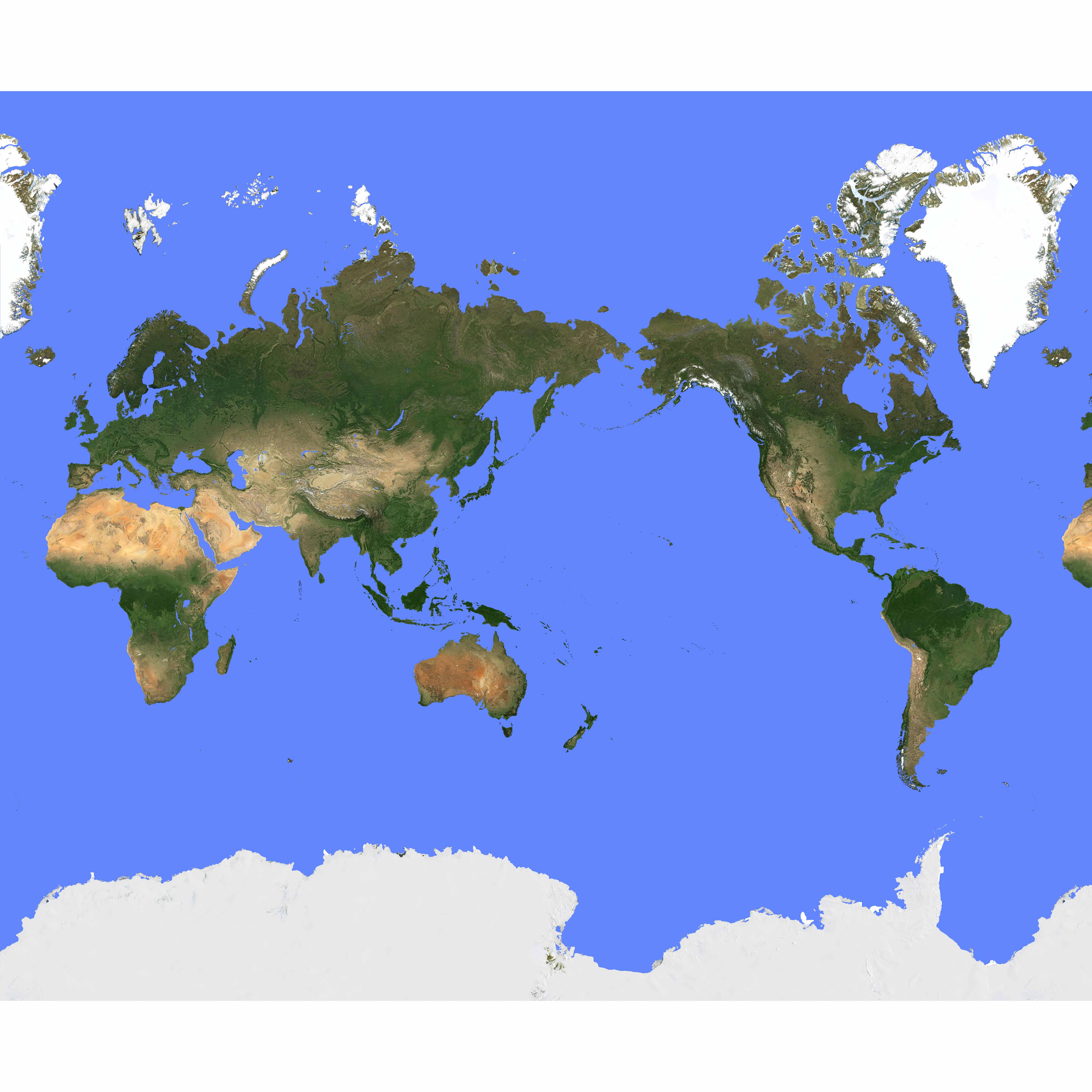
This large-format world chart presents Earth through a Pacific-centered projection, offering children a unique perspective on global geography with detailed terrain visualization. The laminated surface features authentic topographical detail showing mountain ranges, deserts, and ice caps, supporting the Montessori approach to concrete, reality-based learning that helps children understand their place in the world.
“The child is both a hope and a promise for mankind.”— Maria MontessoriEducation and Peace
“The hands are the instruments of man's intelligence.”
— Maria Montessori, The Absorbent Mind
The Large Chart of the World meets young children's profound need to understand their relationship to the wider world through concrete, visual representation. This Pacific-centered projection challenges traditional Europe-centered views, helping children develop global perspective without cultural bias. The laminated chart's topographical features—visible mountain ranges, deserts, and ice caps—transform abstract continents into tangible landforms children can trace with their fingers. In Montessori geography, the world chart serves as children's first comprehensive view of Earth, bridging their understanding from the sensorial globe work to detailed continent studies. The large format allows multiple children to gather around and explore simultaneously, fostering collaborative discovery. Through repeated exposure to this chart's authentic terrain visualization, children internalize Earth's physical geography before moving to political boundaries, following Montessori's principle of presenting the whole before the parts.
Each order includes everything needed for proper presentation and long-term use.
Follow the Montessori method of presentation for optimal child development.
Begin with the Three Period Lesson for continents, pointing to each landmass: 'This is Asia'
Invite children to trace coastlines with their finger, following the laminated surface
Introduce topographical features by having children locate mountain ranges using the terrain visualization
Connect to children's lives by locating their continent, country, and region
Explore ice caps at poles, discussing how white areas represent frozen regions
Every material is carefully selected for durability, safety, and authentic Montessori experience.
Sourced from sustainably managed European forests. Beechwood is chosen for its exceptional durability, smooth grain, and natural warmth that invites touch.
Natural, unbleached cotton in child-friendly colors. The fabric provides the right amount of friction for developing fingers while being gentle on sensitive skin.
Water-based, child-safe finish that meets the strictest European safety standards. Designed to withstand years of daily use without chipping or peeling.
Each material supports multiple areas of child development simultaneously.
Pacific-centered view challenges conventional perspectives and promotes understanding of Earth as interconnected whole.
Detailed terrain features help children distinguish between geographical formations and recognize natural patterns.
Supports fundamental human tendency to explore and understand different regions and peoples of the world.
Facilitates vocabulary expansion through naming continents, oceans, and geographical features.
Designed for child-sized hands
Professional tips from AMI-trained guides to maximize the educational value of this material.
“Present the chart after children have worked extensively with the sandpaper globe to understand land and water divisions”
Use the Pacific-centered projection to discuss different ways of viewing our world, emphasizing no single 'correct' orientation
Create matching exercises using small continent cards that children can hold against the large chart
Regularly reference the chart during cultural presentations, stories, and discussions about animals or foods
Everything you need to know about this material.
This chart aligns with Montessori principles by presenting real, detailed geographical features including authentic topographical details, mountain ranges, and terrain visualization. The concrete, reality-based approach helps children ages 3-6 develop a true understanding of Earth's physical features and their place in the world.
The Pacific-centered view offers children a unique perspective different from traditional Atlantic-centered maps, promoting global awareness and helping them understand that there are multiple ways to view our world. This perspective particularly highlights Asia, Australia, and Pacific regions, supporting comprehensive geographical understanding.
The high-quality laminated surface is designed for daily classroom handling by young children. It resists tears, spills, and frequent touching while maintaining clear visibility of geographical details. The lamination also allows for easy cleaning and ensures the chart remains a long-lasting educational investment.
Children can explore detailed terrain visualization including mountain ranges like the Himalayas and Andes, major deserts such as the Sahara and Gobi, polar ice caps, ocean depths, and continental features. The topographical detail helps children understand Earth's diverse landscapes and climates.
Teachers can use this chart for cultural studies, continent work, land and water form lessons, and global awareness activities. It serves as a reference for discussing different countries, climates, and geographical features while supporting language development through vocabulary building and storytelling about different world regions.
Can't find what you're looking for?
Contact Our Experts
Share your experience with this material and help other educators and parents.


