The Land And Water Forms: Card Set is a category.geography Montessori material designed for children aged 3-6, crafted by Nienhuis Montessori to AMI standards.
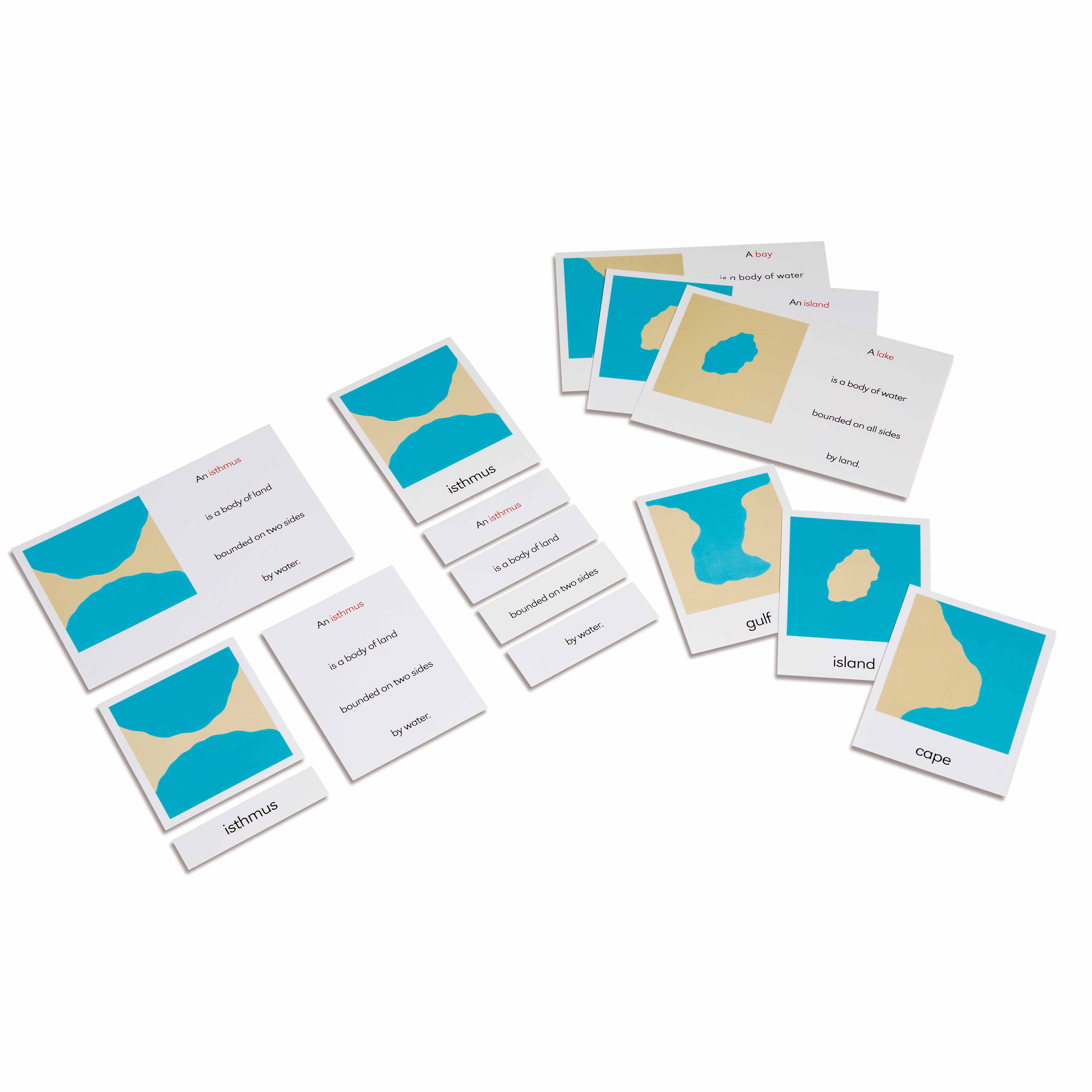
These Land and Water Forms cards introduce children to fundamental geographical features through Montessori's three-part card system. Each set presents clear photographic or illustrated representations of landforms like isthmuses, gulfs, islands, and capes, paired with separate nomenclature labels for matching work. The 9×9 cm cards support the development of geographical vocabulary and visual discrimination while preparing children for more advanced map work.
“Education is a natural process spontaneously carried out by the human individual, and is acquired not by listening to words but by experiences upon the environment.”— Maria MontessoriEducation for a New World
“The child is both a hope and a promise for mankind.”
— Maria Montessori, Education and Peace
The Land and Water Forms Card Set addresses the child's need to understand Earth's physical features during their sensitive period for language and order. These 9×9 cm cards present geographical concepts through concrete visual representations, allowing children to absorb complex terminology like 'isthmus' and 'gulf' when their minds are particularly receptive to new vocabulary. The three-part card format of the Land and Water Forms enables independent work cycles where children match images to labels at their own pace. By isolating each geographical feature on individual cards, the material respects the child's need for clarity and precision in learning. The photographic or illustrated representations on these cards bridge the gap between the child's immediate environment and the wider world, preparing them for abstract map work. Through repeated matching exercises with the Land and Water Forms cards, children build a mental catalog of Earth's features that serves as the foundation for all future geographical study.
Each order includes everything needed for proper presentation and long-term use.
Follow the Montessori method of presentation for optimal child development.
Present three contrasting forms first (island, lake, isthmus). Name each feature while pointing to its picture card
Invite the child to match the label cards to the picture cards, reading each label aloud
Introduce the control cards (picture with label attached) for self-correction
Once familiar with 3-4 forms, play the three-period lesson: 'Show me the peninsula,' 'Which one is the gulf?'
Gradually add more complex forms like strait, archipelago, and system of lakes
Every material is carefully selected for durability, safety, and authentic Montessori experience.
Sourced from sustainably managed European forests. Beechwood is chosen for its exceptional durability, smooth grain, and natural warmth that invites touch.
Natural, unbleached cotton in child-friendly colors. The fabric provides the right amount of friction for developing fingers while being gentle on sensitive skin.
Water-based, child-safe finish that meets the strictest European safety standards. Designed to withstand years of daily use without chipping or peeling.
Each material supports multiple areas of child development simultaneously.
Introduces precise terminology for land and water formations, building the foundation for advanced geography studies.
Develops the ability to distinguish between similar geographical features through careful observation and matching.
Nomenclature cards support early reading skills through word-picture association and label matching.
Encourages logical thinking as children sort and categorize different types of land and water forms.
Designed for child-sized hands
Professional tips from AMI-trained guides to maximize the educational value of this material.
“Store cards in separate envelopes by category (water forms, land forms, combined forms) for easy classroom management”
Create a weekly rotation system, introducing 3-4 new forms each week to maintain engagement
Pair card work with the sandpaper globe to show how blue represents water and brown represents land
Use consistent vocabulary when presenting - always say 'gulf' not 'big bay' to maintain precision
Everything you need to know about this material.
This card set is specifically designed for children ages 3-6 years old, aligning with the Montessori primary/casa curriculum for early geography education.
The set includes three-part cards measuring 9×9 cm each. The exact number of cards varies based on the geographical features covered, typically including control cards with labels, picture cards without labels, and separate label cards for each landform.
The cards introduce fundamental land and water forms including isthmuses, gulfs, islands, capes, peninsulas, bays, straits, lakes, and archipelagos, providing comprehensive coverage of basic geographical vocabulary.
Three-part cards consist of a control card (picture with label), a picture card without label, and a separate label card. Children match the unlabeled picture to the control card, then add the label, promoting independent learning and self-correction.
This material develops geographical vocabulary, visual discrimination, reading readiness, classification skills, and prepares children for more advanced map work and geography studies in elementary years.
Can't find what you're looking for?
Contact Our Experts
Share your experience with this material and help other educators and parents.


