The Four Maps Of North America is a category.geography Montessori material designed for children aged 3-6, crafted by Nienhuis Montessori to AMI standards.
This comprehensive geography set introduces children to North America through four distinct puzzle maps, each highlighting different geographical and political aspects of the continent. The wooden-framed maps feature removable pieces representing countries, states, or regions, complemented by flag pins and control cards that help children connect visual symbols with geographical locations.
“Education is a natural process spontaneously carried out by the human individual, and is acquired not by listening to words but by experiences upon the environment.”— Maria MontessoriEducation for a New World
“The child is both a hope and a promise for mankind.”
— Maria Montessori, Education and Peace
The Four Maps Of North America set embodies Maria Montessori's vision of cosmic education, where geography serves as the foundation for understanding humanity's interconnectedness. Each wooden-framed puzzle map isolates specific geographical knowledge—political boundaries, physical features, or regional divisions—allowing children to build comprehensive understanding through repeated manipulation of removable pieces. The flag pins create concrete connections between abstract symbols and physical locations, while control cards enable independent verification of work. This multi-map approach respects the child's need to move from whole to parts, first grasping North America as a complete continent before differentiating individual countries and states. The tactile nature of lifting and placing each wooden piece engages muscle memory alongside visual learning, creating lasting geographical impressions. By presenting four distinct perspectives of the same continent, children discover that geography encompasses both natural formations and human-created boundaries, laying groundwork for cultural studies.
Each order includes everything needed for proper presentation and long-term use.
Follow the Montessori method of presentation for optimal child development.
Invite the child to remove all pieces from one map, placing them randomly on the mat
Select one piece and trace its outline with your finger, then find its location on the frame
Once pieces are replaced, introduce flag pins by selecting one and finding its corresponding location
Use control cards to verify flag placement, reading country or state names aloud
Each material supports multiple areas of child development simultaneously.
Children develop spatial understanding of North American countries, states, and regions through tactile manipulation of map pieces
Flag identification activities connect visual symbols with countries, building early cultural awareness and respect
Removing and replacing puzzle pieces refines pincer grasp and hand-eye coordination essential for writing
Matching flags to countries and comparing map features develops visual perception and attention to detail
Designed for child-sized hands
Professional tips from AMI-trained guides to maximize the educational value of this material.
“Introduce maps sequentially over several weeks, allowing mastery of one before presenting another”
'This is Canada,' 'Show me Canada,' 'What is this?'
Use maps as springboard for cultural celebrations, focusing on countries during relevant holidays or events
Rotate which map is displayed prominently, maintaining novelty and renewed interest throughout the year
Everything you need to know about this material.
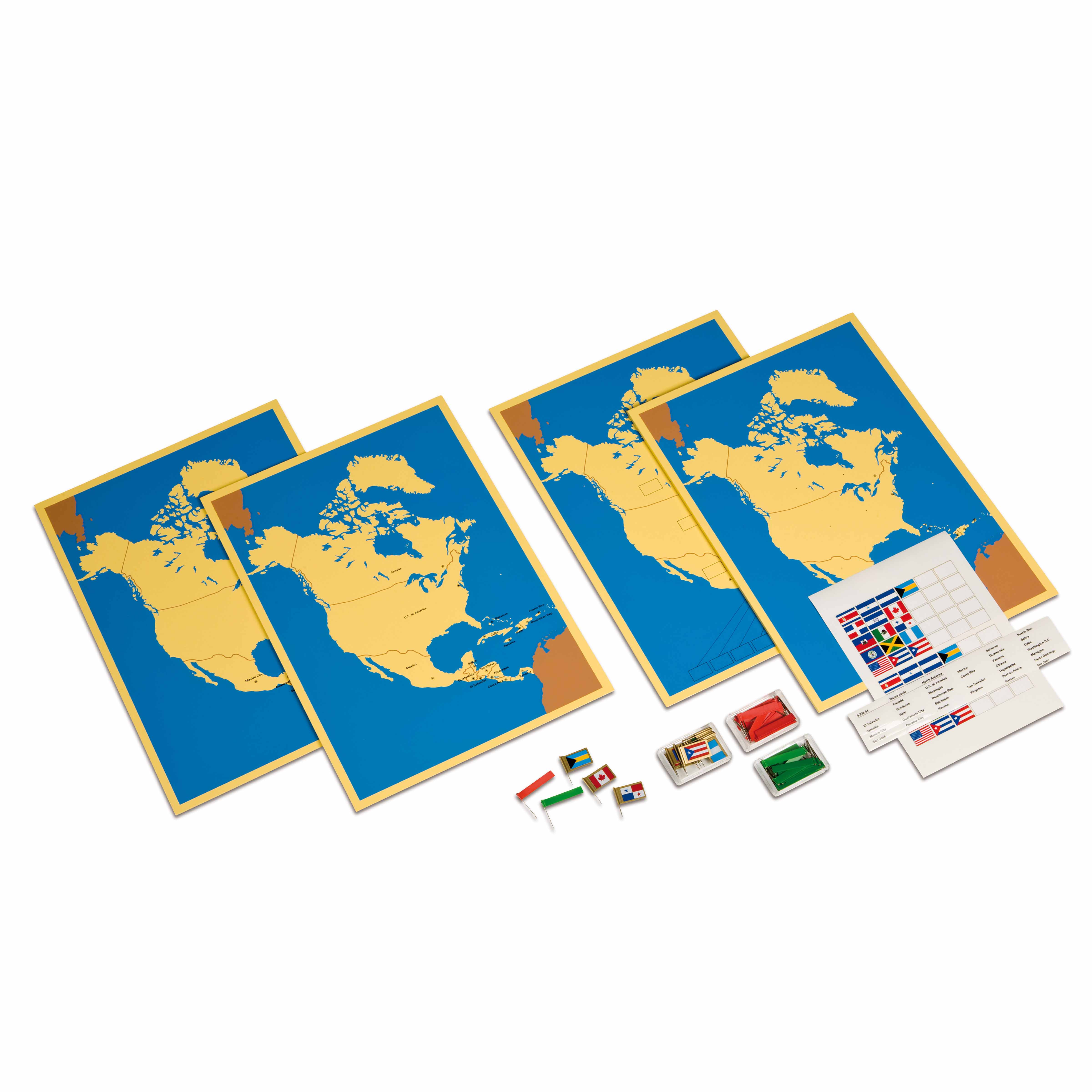
This set includes four wooden-framed puzzle maps of North America: a political map showing countries, a map of the United States showing individual states, a map of Canada showing provinces and territories, and a control map without divisions for children to trace and create their own maps.
Each country or region has corresponding flag pins that children can place on the map pieces. The control cards show the flags alongside country names, helping children make visual connections between national symbols and geographical locations while developing reading skills.
Yes, the puzzle pieces are specifically designed for small hands with knobs or grips for easy manipulation. The pieces are made from durable wood with smooth edges, sized appropriately for this age group to develop fine motor skills while learning geography.
Children develop spatial awareness, visual discrimination, fine motor control, and cultural awareness. They also learn country names, flag recognition, relative sizes and positions of regions, and begin understanding political boundaries while building concentration and problem-solving abilities.
Introduce one map at a time, starting with the simplest (whole continent) before progressing to more detailed versions. Store maps on accessible shelves, demonstrate proper handling of pieces, and encourage children to work at their own pace, using control cards for self-correction.
Can't find what you're looking for?
Contact Our Experts
Share your experience with this material and help other educators and parents.

