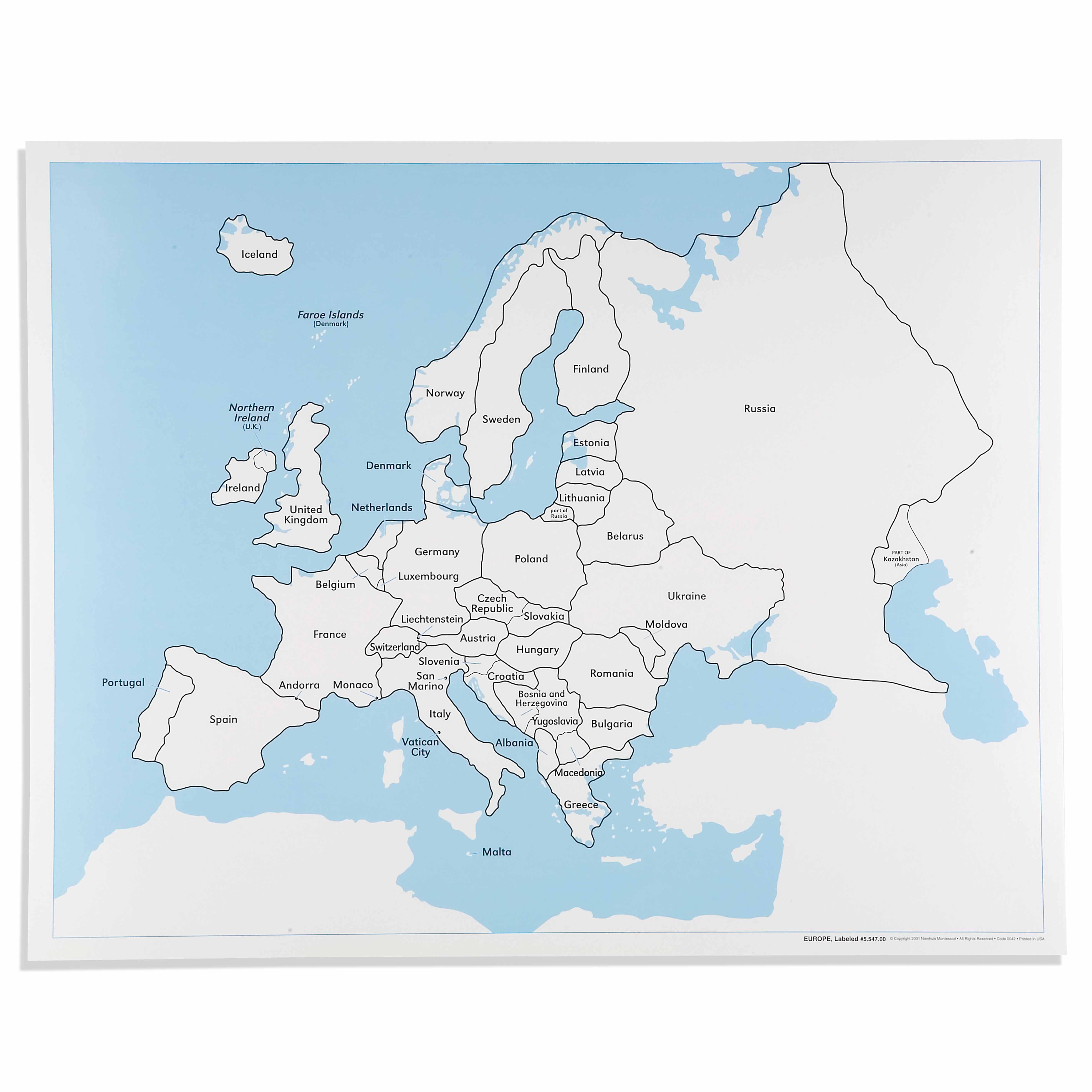
The Europe Control Map: Labeled is a category.geography Montessori material designed for children aged 3-6, crafted by Nienhuis Montessori to AMI standards.
This labeled Europe Control Map serves as an essential reference tool in the Montessori geography curriculum, enabling children to verify their work with puzzle maps and develop spatial awareness of European countries. The clear labeling of nations and water bodies supports independent learning while the durable laminated surface ensures years of classroom use.
“Education is a natural process spontaneously carried out by the human individual, and is acquired not by listening to words but by experiences upon the environment.”— Maria MontessoriEducation for a New World
“The child is both a hope and a promise for mankind.”
— Maria Montessori, Education and Peace
The Europe Control Map: Labeled represents Montessori's concrete approach to abstract geographical concepts, providing children with a visual reference that bridges their sensorial work with puzzle maps to abstract understanding of political boundaries. This laminated control map serves as a self-correcting tool, allowing children to independently verify their placement of puzzle pieces while building mental images of European nations. By offering clear labels for countries and water bodies, this control map respects the child's need for order and precision during the sensitive period for language and spatial relationships. The Europe Control Map transforms geography from memorization into active discovery, where children can trace borders, compare sizes, and observe relationships between neighboring countries. Its durable laminated surface withstands repeated handling as children return to verify their work, building confidence through successful self-correction. This labeled map embodies the Montessori principle of isolating difficulty—presenting political boundaries clearly while children are still developing their understanding of abstract geographical concepts.
Each order includes everything needed for proper presentation and long-term use.
Follow the Montessori method of presentation for optimal child development.
Invite the child to bring the Europe puzzle map to the work area near the control map
Remove puzzle pieces one at a time, placing them on the work surface
Select a puzzle piece and find its match on the control map by comparing shapes
Read the country name on the control map together
Place the puzzle piece in its correct location, using the control map to verify
Continue until all pieces are placed, checking each against the control map
Every material is carefully selected for durability, safety, and authentic Montessori experience.
Sourced from sustainably managed European forests. Beechwood is chosen for its exceptional durability, smooth grain, and natural warmth that invites touch.
Natural, unbleached cotton in child-friendly colors. The fabric provides the right amount of friction for developing fingers while being gentle on sensitive skin.
Water-based, child-safe finish that meets the strictest European safety standards. Designed to withstand years of daily use without chipping or peeling.
Each material supports multiple areas of child development simultaneously.
Builds understanding of European countries, their names, and relative positions through visual reference.
Enables self-correction when working with puzzle maps and other geography materials.
Supports emerging readers with clear country labels and geographical terminology.
Develops understanding of borders, water bodies, and the relationship between nations.
Designed for child-sized hands
Professional tips from AMI-trained guides to maximize the educational value of this material.
“Display the control map at child height to promote independent access and reference throughout the day”
Introduce country names gradually—begin with 3-5 countries and expand as children show readiness
Use the control map during group lessons to discuss current events or cultural studies
Laminate additional blank maps for children to color and label as they progress
Everything you need to know about this material.
The map is typically A3 or similar size (approximately 42 x 30 cm) and is printed on high-quality paper with a durable laminated surface that resists tears and spills, ensuring longevity in classroom use.
Children use this labeled map as a reference guide to check their work when using the Europe puzzle map, promoting self-correction and independent learning. It helps them verify correct placement of countries and learn proper geographical names.
The map clearly labels all European countries with their names, major bodies of water including seas and oceans, and may include capital cities. The labeling uses child-friendly fonts that are easy to read.
Yes, it serves multiple purposes including tracing exercises, coloring activities, flag matching work, capital city identification, and as a reference for cultural studies about European countries and their neighbors.
While designed for ages 3-6, pre-readers can still benefit by matching the shapes and colors to the puzzle map pieces. As reading skills develop, children naturally begin associating the written names with the countries they've been working with.
Can't find what you're looking for?
Contact Our Experts
Share your experience with this material and help other educators and parents.


