The Africa: Waterways (50) is a category.geography Montessori material designed for children aged 3-6, crafted by Nienhuis Montessori to AMI standards.
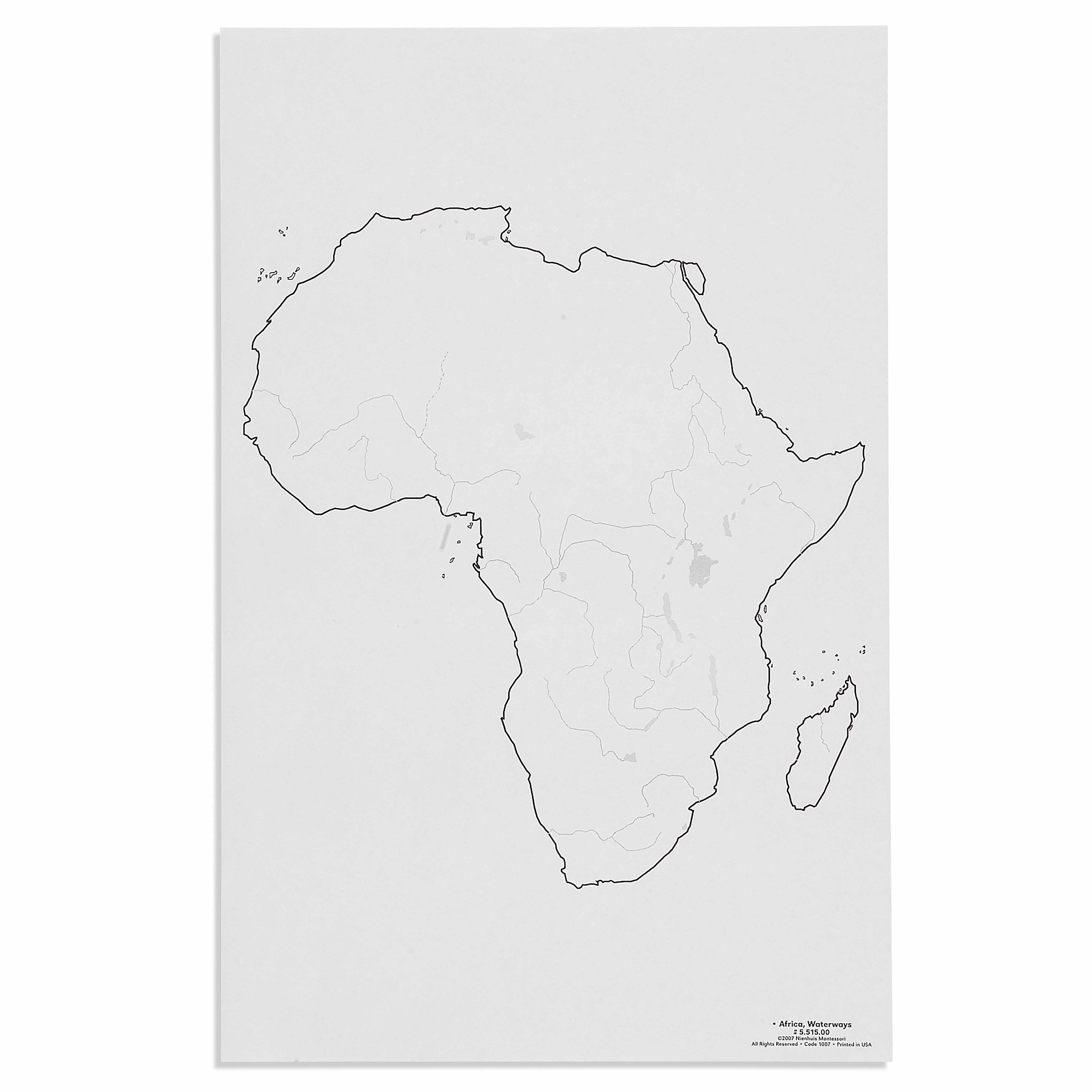
This detailed control map presents Africa's waterways with precise geographical accuracy, allowing children to trace and study the continent's major rivers and water systems. The large-format map features clear outlines and carefully marked waterways, supporting the Montessori approach to concrete geographical learning through visual and tactile exploration.
“Education is a natural process spontaneously carried out by the human individual, and is acquired not by listening to words but by experiences upon the environment.”— Maria MontessoriEducation for a New World
“The child is both a hope and a promise for mankind.”
— Maria Montessori, Education and Peace
The Africa Waterways control map introduces young children to the continent's river systems through concrete visual representation, addressing their developmental need to understand the world's physical features. This large-format geographical map allows children to trace the Nile, Congo, Niger, and other major rivers with their fingers, connecting abstract concepts of water flow to visible pathways. By presenting waterways as distinct blue lines against the continent's outline, the map satisfies children's need for clear, isolated concepts during their sensitive period for order and classification. The control map's precise geographical accuracy respects the child's intelligence, offering real knowledge rather than simplified approximations. Through repeated work with Africa's waterways, children build mental maps of how rivers connect regions, flow toward seas, and create patterns across the landscape. This waterway map serves as a foundation for understanding how water shapes human settlement, agriculture, and cultural development across Africa.
Each order includes everything needed for proper presentation and long-term use.
Follow the Montessori method of presentation for optimal child development.
Begin at the Mediterranean Sea and trace the Nile River south with your finger
Identify where rivers begin (sources) and end (mouths), marking these with small objects
Compare river lengths by tracing each major waterway from source to sea
Notice how rivers branch and merge, creating networks across the continent
Every material is carefully selected for durability, safety, and authentic Montessori experience.
Sourced from sustainably managed European forests. Beechwood is chosen for its exceptional durability, smooth grain, and natural warmth that invites touch.
Natural, unbleached cotton in child-friendly colors. The fabric provides the right amount of friction for developing fingers while being gentle on sensitive skin.
Water-based, child-safe finish that meets the strictest European safety standards. Designed to withstand years of daily use without chipping or peeling.
Each material supports multiple areas of child development simultaneously.
Builds concrete knowledge of Africa's major rivers and water systems through visual study.
Supports tracing and pin-poking activities that refine hand control and precision.
Develops understanding of geographical relationships and continental features.
Encourages independent study and comparison with other geographical materials.
Designed for child-sized hands
Professional tips from AMI-trained guides to maximize the educational value of this material.
“Present one major river system at a time before showing interconnections between waterways”
Keep a spray bottle nearby to demonstrate how water flows downhill toward the ocean
Connect waterway work to practical life by discussing how rivers provide drinking water and transportation
'This is the Nile' (naming), 'Show me the Nile' (recognition), 'What is this?' (recall)
Everything you need to know about this material.
This control map features Africa's major rivers and water systems including the Nile, Congo, Niger, Zambezi, and other significant waterways. Each river is clearly marked and accurately positioned to help children understand the continent's water geography.
Children trace the waterways with their fingers, match river labels to locations, and use it as a reference when working with puzzle maps. The control map serves as a self-correction tool, allowing independent verification of their work with Africa water systems.
This is a large-format control map designed for easy visibility and handling by young children ages 3-6. The generous size allows children to clearly see all waterway details and comfortably trace rivers with their fingers during geography lessons.
This versatile control map can be used both ways - mounted on the wall as a reference during group lessons or laid flat on a table for individual exploration. The durable construction supports repeated handling during hands-on geography activities.
Following Montessori principles, this concrete visual aid helps children ages 3-6 build a sensorial understanding of African geography. By physically tracing waterways and observing their paths, children develop spatial awareness and begin understanding how rivers shape continents.
Can't find what you're looking for?
Contact Our Experts
Share your experience with this material and help other educators and parents.


